
Lots of questions are about the Google Maps API Key.
Here are some important elements:
 Or like this:
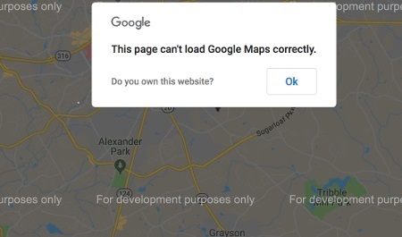
 The most likely reason for this is the settings of your Google Key.
You may have to ‘activate’ your ‘passive’ Key after a trial period of one year.
Go here to find out how to do that: How to activate your Google Key.
There are many APIs that can be activated.
Do you want to know which of these should be activated in any case? Or what would be smart?
Click on the image below to enlarge it.
The most likely reason for this is the settings of your Google Key.
You may have to ‘activate’ your ‘passive’ Key after a trial period of one year.
Go here to find out how to do that: How to activate your Google Key.
There are many APIs that can be activated.
Do you want to know which of these should be activated in any case? Or what would be smart?
Click on the image below to enlarge it.
 Google will advise you to restrict the use of your APIs.
This is unnecessary for use with Tyre, because you only use the Key for yourself. Moreover, it can cause problems, as has often been shown.
So don’t put any restrictions!
Google will advise you to restrict the use of your APIs.
This is unnecessary for use with Tyre, because you only use the Key for yourself. Moreover, it can cause problems, as has often been shown.
So don’t put any restrictions!
 Click here to use our troubleshooter:
the easy way to consult the FAQs!
The Frequently Asked Questions are sorted in five sections:
Click here to use our troubleshooter:
the easy way to consult the FAQs!
The Frequently Asked Questions are sorted in five sections:
- More information about creating your API Key? Click here!
- Do you want to know more about pricing when using a Google Key? Read all about it here!
- On creating or editing your API Key, use only Google Chrome as a browser. Really annoying, but unavoidable, because otherwise lots of unexpected errors may occur.
- Make sure that you have enabled all relevant API Keys: not only API Maps, but also Routes and Places. Do you want to know which APIs should be activated in any case? Or what would be smart? Click here!
Or like this:
The most likely reason for this is the settings of your Google Key.
You may have to ‘activate’ your ‘passive’ Key after a trial period of one year.
Go here to find out how to do that: How to activate your Google Key.
There are many APIs that can be activated.
Do you want to know which of these should be activated in any case? Or what would be smart?
Click on the image below to enlarge it.
Google will advise you to restrict the use of your APIs.
This is unnecessary for use with Tyre, because you only use the Key for yourself. Moreover, it can cause problems, as has often been shown.
So don’t put any restrictions!
Click here to use our troubleshooter:
the easy way to consult the FAQs!
The Frequently Asked Questions are sorted in five sections: Answer
All available languages are displayed in the main page.
You can select your own language directly after downloading: start the setup and choose your own language.
These languages are only available for the program and for the help pages. The website you are reading now, is only available in English.
If you are interested in translating Tyre into your own language: Contact me!
Tranlating is really easy: you don’t have to know anything about programming.
The only thing you need to know, is your own language… 
Answer
Most likely your computer is infected with malware, that is prohibiting the map to be displayed.
Use the malware scanner from Malwarebytes to clean your computer: www.malwarebytes.com/premium/
For your information: some people who were thinking that their computers were free from malware (because they were using a malware scanner themselves already), discovered that the scanner from Malwarebytes detected some other malware, and that removing that malware solved their problem!
Answer
This problem is caused by some setting on the Google Maps server. (It was not there before.) You will have this problem when your screen settings are different from the default Windows screen settings. Obviously the display size for items on your computer has changed from 96 dpi to (most likely) 120 dpi.
If you have this problem, go to the ‘Preferences’ window, and select the ‘Google Maps – Map’ tab.
Go to the slider that says ‘Size (map, font, images)’, and move the slider to the right. In most cases two ticks will do. (Move the slider to the center of the bar.)
Answer
If you are using internet protection software, e.g. a sophisticated firewall, that software may prohibit downloading EXE files or it may cause an incorrect download.
In that case, shut down your protection software an retry downloading. After downloading, reactivate your protection software.
Answer
Tyre will only save the waypoints (or the points of interest) with their coordinates, and (if the relevant option is set) information about the route and altitude. It will not save any other data, such as references to additional images.
Answer
If you want to run the setup and install Tyre on your computer, you must have administrator rights. Otherwise, you may encounter error messages.
So, if you do not have administrator rights (i.e. if are using an account with limited access rights), it maybe impossible to install Tyre properly.
If you receive error messages about missing files or about files that cannot be installed, here is what you have to do: log off from your current account, log on as a user with administrator rights and rerun the setup application.
To install Tyre from your computer to a portable device (USB stick), you don’t need to have administrator rights.
Answer
Some options can only be set and some functions can only be executed if you are logged in with administrator rights.
If you are unable to connect (associate) file types with Tyre (*.itn; *.ov2; *.gpx; *.csv), or in case you cannot repair the Google Earth installation, you should log off and then log in again with administrator rights. Or you should contact your administrator.
Answer
No, unfortunately not. At least not in the near future. If I learn how to write applications for Mac computers or for Linux/Ubuntu, I will reconsider this question.
For the time being, you might consider installing a Windows emulator (like WINE, a piece of free software) on your computer. It will create a Windows environment on your computer. You can use that environment to run Tyre.
Answer
Yes, you can. But you should do this only if you have to!
After installing Tyre, follow these steps:
- Create the new folder that you want to use.
- Move all files from ‘C:\Users\<User Name>\AppData\Roaming\Tyre’ to the new folder and delete the old folder.
- Open NotePad and enter the following text:[Tyre] NewPath=PathFor Path you enter the new path. Be sure to enter an existing path that you have access to. Otherwise the old path will be created and used again. Be also sure NOT to end the path with a backslash, e.g. ‘D:\Tyre’ is correct, ‘D:\Tyre\’ is not correct.
- Save the file into your Windows folder as ‘TyrePath.txt’.
Answer
After reversing your route, you will have to check your itinerary. Some waypoints need to be moved, e.g. when on one side of a highway.
Answer
This message means that some variable does not exist or cannot be initialized.
It is necessary to remove Tyre completely from your computer and to re-install it. We have created a tool that can do the cleaning job for you. Click here to download the tool.
If you want to do it yourself, follow these steps:
– Remove Tyre from your computer.
– Remove the following key (and all of its sub keys) from the registry: HKEY_CURRENT_USER\Software\Tyre
If there are still Tyre files on your disk, remove them too:
– Remove the folder C:\Program Files\Tyre and all of its contents.
– Remove the Tyre Application Data folder and all of its contents.
You can find the Application Data folder here:
‘C:\Users\<User Name>\AppData\Roaming\Tyre’.
Done this? Then restart your computer, download and install Tyre again.
Answer
This message is pretty much the same as the previous one.
Therefore: execute the actions mentioned above.
In addition, (re-)register the jscript.dll and the vbscript.dll files. If you don’t know how to do that, follow these steps:
– Press WinKey+R (WinKey is the key with the Windows flag, next to the Ctrl-key on your keyboard).
– You will see a window in which you can enter a command.
– Enter this command: regsvr32 jscript.dll
– Then press Enter.
– Repeat the same steps for this command: regsvr32 vbscript.dll
Answer
Yes, that is possible. Open the preferences and select the ‘Google Maps – Route’ tab. On that tab you can switch between walking, cycling and driving/riding.
Answer
This is an option for some file types: *.gpx (GPS Exchange files), *.kml and *.kmz (Google files). Normally these files are saved in the UTF-8 format. If you don’t encounter any problems, leave the preference the way it is (checked).
There are some applications, however, that are not able to handle these file types in UTF-8 format, e.g. POIEdit. If you want to use one of the file types mentioned in such an application, uncheck the preference before saving the file. The file will be saved in ANSI format.
But you have to realize that the ANSI format has less possibilities than the UTF-8 format. Therefore, if you use ANSI instead of UTF-8, you may get error messages from Google Earth or other applications.
Answer
You must have administrator rights to run the Tyre installation. If not, the installation will not be executed properly. Some necessary files will be missing. This will cause errors when you try to run Tyre.
Answer
This is the same as above: you must have administrator rights to run the Tyre installation.
Answer
Yes, that is possible, but you cannot use the setup file to do that. To install Tyre on a portable device, you have to install it on your computer first.
Once Tyre is installed on your computer, you can install it to a portable device from there: from the ‘Tools’ menu, select ‘Install Tyre to USB stick…’
If you have a U3 stick or if you have PortableApps.com installed on your USB stick, you can even install Tyre as a U3 application or as a PortableApps.com application.
Answer
Tyre has the perfect way to solve this problem: select the waypoint that you want to use as your first waypoint.
Then, from the ‘Waypoint’ menu select the ‘First waypoint…’ option.
That is all! Your route will be reorganized with a new start and finish.
Answer
You can do the following: open your local network connections (just click the network icon in the tray), find your VPN connection, right-click it, and select Properties. Click the Networking tab, select Internet Protocol Version 4 (TCP/IPv4), click Properties, click Advanced, then uncheck Use default gateway on remote network. Press OK until all the dialog boxes are closed. That’s it!
20
21
Answer
If you want to use the Google Maps option, executing JavaScript must be enabled on your computer. Make sure this is the case.
This setting can be changed using your web browser.
Click here to find out how to do it.
Answer
Yes, they are. If they are not in your instance of Tyre, maybe you have disabled that particular option.
1. To enable draggable route lines, select ‘Preferences’ from the ‘Tools’ menu. The ‘Preferences’ window will appear. From that window, select the ‘Google Maps – Route’ tab, and check the option that says ‘Use draggable route lines’.
2. If you have disabled the option, things work a little bit different:
– Click the route line somewhere.
– A new waypoint will be inserted on that location.
– Drag that new waypoint to the location where you want it.
– The route line will be adapted accordingly.
Answer
This problem can have several causes:
- You have placed one or more of your waypoints too far from a road. Relocate them.
- You have placed one or more of your waypoints in an area (or country) that is not part of the Google Maps directions database yet. You should realize that Tyre uses the functionality of Google Maps. Not all roads on earth are in the Google Maps directions database. That means: you can see those roads and locate waypoints on them, but Google Maps will not be able to calculate directions for those roads (and waypoints). There is one positive element: the Google Maps directions database is still growing…
- Maybe you have selected ‘Cycle’ from the preferences. You should realize that coverage for cycling routes is rather limited in Google Maps.
Answer
Maybe you have a very active firewall that prohibits Tyre to access the Internet. Try this:
– Shut down your firewall temporarily.
– Try to run Tyre. If there are no error messages, the ‘error’ came from your firewall.
– Rerun your firewall and adapt its settings to allow Tyre to access the Internet.
Answer
Normally, waypoints will be moved to the nearest road, if you create them on another location (no road). This is done to make plotting routes easier.
But if you do not want that (for whatever reason), you can change that: select the ‘Preferences’ option from the ‘Tools’ menu. Then select the ‘Google Maps – Map’ tab, and uncheck the ‘Place waypoints exactly on roads’ option.
If you do this, you better uncheck right away the ‘Calculate’ option, because routes will always be calculated using the roads. So, if you are calculating a route, using waypoints that are spread out over the map, your route will look terrible.
Answer
Apparently you have an older version of Tyre. Due to changes on the Google Maps server, it is no longer possible to use this older version together with Google Maps.
Update your version of Tyre to the most recent one.
Answer
This can be done easily:
– Open the ‘Preferences’ window from the ‘Tools’ menu.
– Select the ‘Google Maps – Route’ tab.
– Check the ‘Display distance in miles’ option.
Answer
It is important to localize Tyre for a proper postcode search. Localizing Tyre can be done on the ‘Google Maps – Map’ tab from the ‘Preferences’ window: set the ‘Google Maps’ location to your own country. E.g. https://maps.google.co.uk
Google seems to use different databases, because if you search for postcodes on Google’s own website, the proper place is returned. Programmers like me cannot use the Google’s website interface directly. We have to use API functions (if that means anything to you). Using those API functions, another interface and another database is used. I don’t understand why. But that is how it is.
Answer
Tyre reads the Google Maps database using your internet connection. If the map does not accept a waypoint on a particular location, the location is not a valid road or it is closed (according to Google Maps).
If you want your waypoints on that location anyway (you are sure there is a road and it is open), you can do the following:
– Open the ‘Preferences’ window and select the ‘Google Maps – Map’ tab.
– Uncheck the ‘Locate waypoints exactly on roads’ option.
Now you can place your waypoints anywhere you want them.
But: calculating your trip will not work properly (it will use the Google Maps database again).
That is no problem, if your TomTom knows that the road is open: your TomTom will calculate its own route, using the waypoints that you feed it.
Answer
This problem is caused by an error in the Google Maps database. For some reason several passes in the Alps (and maybe elsewhere) are not known as roads that you can drive on. That is why Google Maps is calculating a weird route to get you to your destination.
This is what we recommend: turn off the date via the ‘Ignore Seasonal Closures’ button (above the map, in the center).
Answer
This feature only works if street view is available for a particular area.
Answer
A route can only be printed, if it has been calculated. So, make sure this is done first.
If calculating does not start automatically, click the ‘Calculate’ button.
After the route has been calculated, there are two options for printing the route:
 – Print your route as text (road book).
 – Print your route as image (map).
Answer
There might a problem with the security settings on your computer.
Maybe you have a very active firewall that prohibits Tyre to access the Internet. Try this:
– Shut down your firewall temporarily.
– Try to run Tyre. If there are no error messages, the ‘error’ came from your firewall.
– Rerun your firewall and adapt its settings to allow Tyre to access the Internet.
Answer
This behavior may occur when your file contains a lot of waypoints (or POIs). It is just Windows slowing down as memory fills up. Depending on the number of waypoints/POIs and the speed of your computer, Tyre may seem to hang. It is not really hanging, but it might take a lot of time for the activity to complete.
I recommend to use a maximum of 100 waypoints or POIs for one file. If there are more, split the file, using ‘Split’ or ‘Reduce’ from the ‘File’ menu.
Answer
If you only see a message (with the Tyre logo) about reading and waiting, and the map is not coming up, there is most likely a problem with your Google API Key.
If your Key is invalid, it wil cause all kinds of problems on your map: straight lines connecting the waypoints, no searsch results, problems in manipulating waypoints, etc.
To get a valid Google API Key, you have to finish the process of creating the key completely, including the billing option.
And also important:
– Make sure that you have enabled all relevant API Keys: not only API Maps, but also Routes and Places.
– When creating or modifying the Google API Key, Google Chrome should definitely be used as a browser (annoying, but true).
However, there may be another reason for this behavior. In some situations the problem has to do with Tyre’s internal browser. The exact cause for this problem could not be located yet. We are sorry about that.
However, there is a solution that helps for most computers. If not, there is a workaround.
This is the solution: remove Tyre completely and re-install the program.
NOTE: removing Tyre completely is NOT the same as just uninstalling it. How to remove Tyre completely, can be found by clicking here.
And this is the workaround: just create a new user account on your computer. Tyre will work as designed for the new user.
It is mysterious why this works. There must be some security issue in IE that we did not detect so far…
Most users will find a solution after clicking here.
| Go here: Google API Console. Click the image to the right to enlarge it, and to see the steps to follow. – Go to the ‘Dashboard’. (Red arrow) – Check the APIs. (Green arrow) – Add APIs, if necessary. (Blue arrow) |  |
Answer
The answer to this question depends on your preferences:
If you have disabled the ‘Use draggable route lines’ from the preferences, things are like this:
- Make sure that the route has been calculated (the route line must be visible).
- Click the route line somewhere.
- A new waypoint will be inserted on that location.
- Make sure that the route has been calculated (the route line must be visible).
- Move the mouse cursor over the route line.
- You will see it getting another shape (a small circle will be added on the route line).
- Grab the route line with your mouse and move it to another location.
- A new waypoint will be created (an inserted into the list) on the location where you release the mouse.
Answer
This may be the result if the settings for the Windows font size have been changed.
If this problem occurs, reset the Windows font settings to the default.
When, as a result the letters on the screen are too small, it is better to adapt the screen resolution than the Windows font size.
18. The route line connects the waypoints with a straight line instead of lines following the roads.
Answer
The most likely reason for this behaviour is a problem with your Google API Key.
If your Key is invalid, it wil cause all kinds of problems on your map: straight lines connecting the waypoints, no searsch results, problems in manipulating waypoints, etc.
To get a valid Google API Key, you have to finish the process of creating the key completely, including the billing option.
And also important:
– Make sure that you have enabled all relevant API Keys: not only API Maps, but also Routes and Places.
– When creating or modifying the Google API Key, Google Chrome should definitely be used as a browser (annoying, but true).
| Go here: Google API Console. Click the image to the right to enlarge it, and to see the steps to follow. – Go to the ‘Dashboard’. (Red arrow) – Check the APIs. (Green arrow) – Add APIs, if necessary. (Blue arrow) | |